I want you to think of an island and what that means to you. Go on. Imagine an island. What do you see? I reckon the first thing that popped into your head was the stereotypical deserted island. A small plot, not too big, maybe about the size of a football pitch complete with palm trees, rolling dunes, and blue waters on all sides, as far as the eye can see. Or perhaps you thought of the jagged rocky outcrops of Ireland that Luke Skywalker was hanging out on in the latest Star Wars film. Those are some good examples. The island I'm living on for the year is a little different though.
Certainly it's in a warm climate with beautiful sparkling water surrounding it, but there is a lot more drama happening on the sand than one might suppose. The island I'll be living on for the year is called Bogue Banks and it is part of the barrier island chain known as the Outer Banks. This 200 mile chain of land runs from Currituck Banks in the north all the way south and east to Bogue Banks.
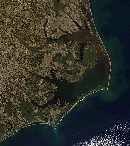 |
| A satellite camera view of the Outer Banks. Photo by NASA. |
According to Wikipedia, "
Barrier islands are coastal landforms and a type of dune system that are exceptionally flat or lumpy areas of sand that form by wave and tidal action parallel to the mainland coast." Upon first inspection, one notable feature of the Outer Banks is how skinny they are. In most spots they can be several hundred feet wide with the widest point being three miles. I noticed this one evening when I was driving to the Bogue Inlet Fishing Pier with friends. As we traveled along Route 58, I looked to the left and the right.
To the left, oceanfront property seemed to be marching towards the water both as a result of economic demands for beachfront property and the constant erosive march of the sand, wind, and waves. To the right, the calmer waters of Bogue Sound were just visible beyond the trees that hid smaller, more reasonably sized homes in comparison to the monster condos and houses on stilts that tower over them on the other side of the road.
 |
| Sunset at Bogue Inlet Fishing Pier in Emerald Isle, NC. Photo by me. |
In his 1983 documentary,
The Beaches Are Moving, geologist Orrin Pilkey lambasted the continued construction of beachfront property, destruction of the dunes, and ignorance of property owners to the process of barrier island formation and the creative destruction that occurs yearly, monthly, and even daily as the sandy base of the islands moves from the west to the east.
In nature, change is the name of the game, and if you don't adapt, too bad. Nature reminds us of this all the time. Hurricane Harvey recently proved this with Houston; flooding city streets and homes, while 120-130 mph winds blasted through the city tossing trees, signs, and other debris around like a leafblower from Hell. With past storms like Hurricane Matthew (2016) and Floyd (1999) devastating the islands and monstrous storms like Hurricane Irma on the horizon, it is frankly shocking that the islands have lasted for as long as they have.
While the islands have been shrinking in parts, this isn't necessarily cause for alarm. From a natural point of view the constantly shifting sands building up, washing away, and building up again confirms Nature's preference for change over stagnation. The tides are an excellent example of this. Every day, water rushes over the intertidal zone and up to the high water mark at the foot of the dunes, covering the sands with salt water. Then just as soon as they have risen, they fall away revealing a bounty of food for migrating shorebirds. As I walked the beach this afternoon, I watched willets (
Tringa semipalmatus) and sanderlings (
Calidris alba) run to and fro from the crashing surf.
 |
| Willet in the surf. Photo by me. |
 |
| Juvenile sanderling. Photo by me. |
They sidestepped walkers and people playing frisbee, while out over the surf, black terns (
Chlidonias niger) and brown pelicans (
Pelicanus occidentalis) glided over the roiling waves. I thought about the coming hurricane and how it might change the islands if it came our way.
 |
| Brown pelican over surf. Photo by me. |
 |
| Black terns. Photo by me. |
My backup plan is to head inland to Raleigh just in case the storm decided Florida wasn't a satisfying enough target for its impending wrath. Hopefully the islands will still be there if I have to go. Nothing would be more anticlimactic and devastating if after a fresh start, Nature decided to take aim and wash it all away. I have hope though. The islands have survived storms before and will likely be here for some time. The only thing we don't know is for how long and I think we must consider long and hard whether our continued pressure is really worth placing on land that can just barely support vegetation, let alone more houses. Only time will tell perhaps, but even that seems to be running out.
"We see that everything in Nature called destruction must be creation - a change from beauty to beauty." - John Muir


Comments
Post a Comment